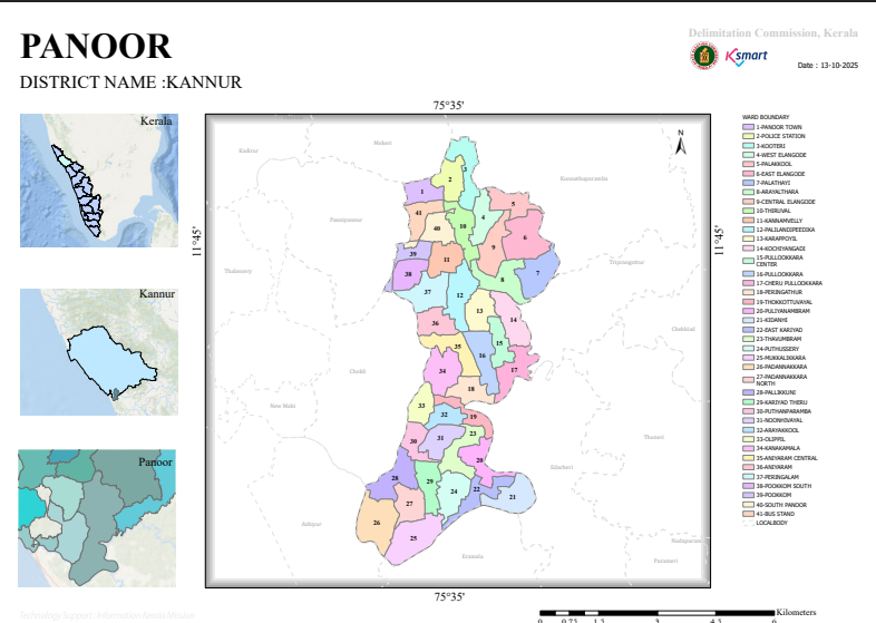
The order finalizes the division of Panoor Municipality into electoral wards for municipal elections.
Key Decisions
- The municipality will have 41 wards.
- Ward boundaries were finalized after:
- Publication of draft proposals on 18 November 2024.
- Public objections and suggestions accepted until 4 December 2024.
- Review, hearings, and consideration of all objections.
- The final ward structure is issued under Section 69 of the Kerala Municipality Act, 1994.
Ward Distribution
The municipality is divided into 41 wards, each with a population generally ranging from 1,272 to 1,540 residents, indicating an effort to maintain population balance across wards.
- 1-Panoor Town
- 2-Police Station
- 3-Kooteri
- 4-West Elankode
- 5-Palakkool
- 6-East Elankode
- 7-Palathayi
- 8-Aryalthara
- 9-Central Elankode
- 10-Thiruval
- 11-Kannamvelli
- 12-Palilandi Peedika
- 13-Karalappoyil
- 14-Kochiyangadi
- 15-Pullookkara Center
- 16-Pullookkara
- 17-Cheru Pullookkara
- 18-Peringathur
- 19-Thokkottu Vayal
- 20-Puliyanpram
- 21-Kidanji
- 22-East Kariyad
- 23-Thavooram
- 24-Puthusseri
- 25-Mukkalikkara
- 26-Padannakkara
- 27-Padannakkara North
- 28-Pallikkuni
- 29-Kariyad Theru
- 30-Puthanparamb
- 31-Nunjivayal
- 32-Arayakkool
- 33-Odippil
- 34-Kanakamala
- 35-Aniyaram Center
- 36-Aniyaram
- 37-Peringalam
- 38-Pookkom South
- 39-Pookkom
- 40-Thekke Panoor
- 41-Bus Stand
Boundary Methodology
Ward boundaries are defined using:
- Roads and highways
- Canals
- Rivers and streams
- Village boundaries
- Panchayat boundaries
- Footpaths and local landmarks
- Schools, temples, mosques, and public buildings
This approach creates clearly identifiable electoral boundaries for administration and elections.
Geographic Coverage
The municipality includes urban, semi-urban, river-side, and border areas adjoining neighboring panchayats and villages, with boundaries frequently following natural and infrastructure features.
Conclusion
The document is the final legally approved ward delimitation order for Panoor Municipality, Kannur District, establishing 41 electoral wards with balanced populations and clearly defined boundaries. It supersedes the draft proposal after public consultation and serves as the basis for future municipal elections in Panoor.